Created by Microsoft Copilot
Remember the days when you used to print MapQuest maps from the computer to follow the turn-by-turn directions from the page while you were driving? Not only was this incredibly dangerous to be looking over at (or holding!) a sheet of paper while you drove, but also wasteful of paper in general. Technology eventually evolved and portable navigation units for the car became common. But these still required mounting a unit to your dashboard or vent and using up the precious 12V adapter of the car for power unless you had it hard-wired.
Then we started using our smartphones on similar mounts, some still do. The latest vehicles have built-in screens with access to OEM mapping software or software like Apple CarPlay or Android Auto. Navigation apps in general have become so advanced that we now use them for walking directions, parking, gas stations, even traffic reports as well.
There are a few navigation apps that most people rely on as being among the best for various reasons. The top three are Google Maps, Waze (which was acquired by Google in 2013), and Apple Maps. All three accomplish many of the same things with similar features. But they each excel in different ways. When should you use which one and for what? Here’s our take.
The Best Navigation App For Walking Directions: Google Maps
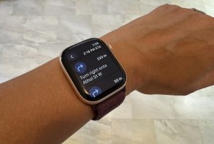
Google Maps is great for navigating by both car and on foot, but I find it particularly exceptional for walking directions. You can type in a destination then map your route as you go, with prompts each time you need to make a left or right turn. It’s easy to follow, especially if you call up the map on a compatible smartwatch like an Apple Watch.
 Google recently enhanced Google Maps with Gemini AI, adding new features for both driving and walking directions. Along with standard navigation assistance, you can also get advice on where to go. Ask it for “things to do with friends at night” for example, then explore the curated selection of options. Narrow down the search by category, read a synopsis of reviews, even ask questions like if there’s a cover charge, full bar, outdoor seating, or hours of operation. This feature is only in the U.S. right now but is expected to come to Canada.
 Another aspect that includes walking directions in the process is with more enhanced driving directions. Once you arrive at your destination, it helps you find nearby parking spots then provides walking directions from the parking lot to the doorstep of the building or house. It’s a seamless process.
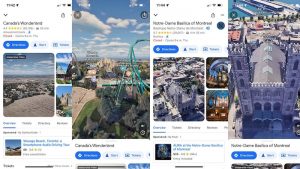
There’s also Street View and AR walking navigation so you can easily orient yourself and see more than a static two-dimensional map. Google added immersive views for five Canadian cities earlier this year, including Montreal, Calgary, Toronto, Ottawa, and Edmonton, which uses computer vision and AI to show lifelike imagery of landmarks and popular destinations.
Download Google Maps for Android
Download Google Maps for iOS
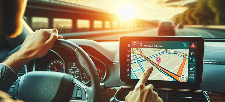
The Best Navigation App For Driving Directions: Waze
 Waze has been my go-to driving navigation app for years. It’s easy to access through Apple CarPlay or Android Auto in the latest vehicles with built-in dashboard systems. As a crowdsourced service, Waze, which is owned by Google, leverages input from drivers and passengers on the road who submit reports about things like heavy traffic, accidents, even police ahead or road closures. The maps are updated immediately, and you’re re-routed if needed.
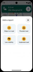
A new feature coming to Waze makes it easier for drivers to advise of things through Conversational Reporting. Tap a button and use natural language to describe what you’re seeing, like an object on the road, a stopped vehicle, a pothole, or unusually heavy traffic. It’s no longer just a matter of selecting from a pre-determined list of options and it’s all done by voice. Conversational Reporting is currently in beta but will be officially coming soon.
Waze is also adding school zones to the maps so drivers can be encouraged to be extra cautious in these areas. Of course, there’s also fun navigation voices you can choose from, including limited ones announced all year ‘round, form Halloween or holiday themed, to movies (Dan Aykroyd for Ghostbusters) and other celebrity voices. Recently, Waze also added access to Apple Music from its CarPlay interface a few years ago along with better navigation around roundabouts, advance alerts of emergency vehicles, alerts about upcoming speed limit changes, and even detailed information about parking garages, including cost, valet options, if they have EV charging stations, and if they’re accessible.
Download Waze for Android
Download Waze for iOS
The Best Navigation App For iPhone Users: Apple Maps
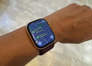 Apple Maps remains the best navigation app for iPhone users. It’s the one I use to drop a PIN for my car after I park in a busy lot, or that friends use to share their drive when we’re meeting for a ladies’ dinner so everyone knows when everyone will arrive. Apple Maps continues to improve over time, with a cleaner, simpler look. From walking to driving directions, you can view everything on your phone or even an Apple Watch. So, you can keep your phone tucked in your pocket while you get where you need to go on foot. It, of course, works with Apple CarPlay as well. You can report incidents with a tap, like a crash, hazard, or speed check. Save favourite locations and view and save curated guides for destination cities you might be visiting.
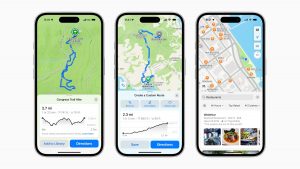 In iOS 18 (as well as iPadOS 18, macOS Sequoia, and watchOS 11), there are new features as well. You can get detailed national park hikes and topographic maps for your next hiking or cycling trip, for example. You can even download hikes to use offline and save them to the Apple Watch.
Download Apple Maps for iOS
Download Them All
The great thing about these three top navigations apps is that they are free to download. Google Maps comes already loaded on Android phones and Apple Maps on iOS devices, so you can start playing around with them right out of the gate.
While my Mazda has its own built-in mapping, I still upgraded to include CarPlay so I can plug my phone in and access Waze when I drive. But if I’m navigating downtown Toronto or in an unfamiliar city on foot, I will always use Google Maps to direct me while I walk. It’s even great for finding hotspots nearby to grab a drink or a quick patio lunch.
Apple Maps, meanwhile, is a wonderfully collaborative app that works seamlessly with iPhone and Apple Watch. It’s equally ideal for both driving and walking directions.
You may find over time that you prefer one navigation app over the other. But with exciting new features consistently coming to all three, you’ll find that they each have their place on your phone. And most importantly, they save you from printing mountains of paper of having to buy a third party device to help you get to where you need to go.
-30-
Related: Tech for the Road