The use of new technologies that collect data about how we use our public spaces, how we navigate the urban environment, how we can best enjoy our city, can bring real advantages to the city and its citizens.
The use of so-called traffic tech and an array of urban sensors that collect data in public places can also heighten concerns about risks to personal privacy and data security, not to mention unwanted surveillance or the inappropriate use of public resources.
Cities are advised to avoid unnecessary data collection, and to follow concepts of data minimization, as a way to reduce such risks and concerns. There’s a clear need for guidelines and regulations about any data collection in public space, including informed consent.
So being open and transparent about collected data and its uses can help reduce some concerns. Cities around the world are looking at safe and useful ways to share the data they collect, and many – including Toronto – encourage citizens to also use, analyze and take advantage of the data.
It’s all about them, after all.
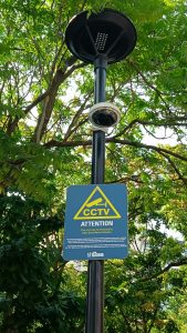
Enjoy a walk in the park and you will knowingly – or not – pass by many devices, sensors, cameras, and other technologies installed by public agencies in public spaces. Photo by Lee Rickwood.
Walk though any major city these days, and you will knowingly – or not – pass by many devices, sensors, gadgets, cameras, and other technologies that are installed by public agencies in public spaces (the use of cameras and surveillance technology by public and private entities is another story altogether).
In Toronto like many other cities, urban managers use sensors for things like road safety and transportation (traffic cameras, pedestrian crosswalks, bike usage, and so on), building security (such as CCTV cameras and mobile device trackers), civic upkeep and asset management (including garbage bins and water meters), and services of convenience for the public (like public Wi-Fi or air quality monitoring).
Cuckoos, Chirps and the Canadian Melody
To many citizens in Toronto, the most representative sound of their city is the familiar ‘doors are closing’ chime on the subway.
But to pedestrians – our urban foot soldiers – the most prototypical sound may be the cuckoo and chirping sounds at our crosswalks. That is, if you know how to activate them.
There are well over 1,200 signalized intersections in Toronto, and between 20 and 30
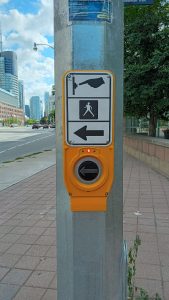
There are well over 1,200 signalized intersections in Toronto, updated with Accessible Pedestrian Signal (APS) technology. Photo by Lee Rickwood.
locations are upgraded every year to the latest technology, known as Accessible Pedestrian Signals (APS). They emit two different audible tones to indicate safe crossing (a third sounds is a locator, so folks with visual impairments can find the device at the intersection).
A cuckoo sound means pedestrians can cross the intersection safely in a north-south direction; a bird-like chirp or the new Canadian Melody tone means people can cross east-west.
But to get these audible indicators, the crosswalk button must be pushed and held for at least three seconds (a loud click sound should confirm the setting). These devices are not data collectors, but the number of button pushes at a certain location can be useful to urban planners trying to merge pedestrian and vehicular traffic in a safe and seamless way.
Seeing Red: Speed and Traffic Light Cameras
Of course, sensors and timers are used on roadways and at intersections to monitor vehicular traffic, including volumes and speeds, to get the safest and most expedient traffic flow. Red-light cameras and speed cameras also utilize sensor technology to catch and penalize driver committing infractions (a fact which continues to irk some citizens, despite long-standing traffic laws, rules, and regulations).
Common types of traffic sensors include inductive loop sensors, which are embedded beneath the road surface; they detect vehicular traffic by measuring changes in nearby magnetic fields. Infrared and microwave sensors can measure traffic flow by detecting interruptions in their signal or light beams.
Newer systems that combine input from several devices (video cameras, radar systems, and inductive loop sensors can be connected on a wireless 5G network, for example) bring greater accuracy and reliability to gathered data. And sensors with built-in artificial intelligence (AI) capabilities can be used to gather data and inform civic decision-making.
Of course, traffic cameras, CCTV systems, and image processing algorithms are nearly ubiquitous in the city, monitoring both vehicular and pedestrian traffic.
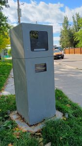
With 75 newly installed speed cameras, traffic managers and enforcement agents can make use of data collection and analysis to consider vehicle speed and collision history city-wide. Photo by Lee Rickwood.
Citizen reaction and response to the use of automated speed enforcement (ASE) cameras is well-known, if not well-appreciated; many cameras have been vandalized, some repeatedly. But 75 newly installed speed cameras (there are about 150 in the city at this point; some are pole-mounted, some are mobile) provide data collection for analysis to consider vehicle speed and collision history city-wide. It’s a way to identify locations with the most problematic vehicle speeds and provide additional safety benefits there.
There are also nearly 350 CCTV-type video cameras installed on major expressways and many arterial streets in the city. Signalized intersections where these cameras are mounted are monitored 24/7 at Toronto’s RESCU traffic operations centre.
Staff there can remotely control traffic signals based on the images they see, and then they can check their adjustments in real-time. Video feeds from these cameras are provided to TV stations, like CP24, and thus to the public as real-time updates on traffic conditions they may encounter.
Additional cameras were to be added this year, prioritizing long-term construction projects (like on the Gardiner Expressway) and in preparation for traffic at special events such as next year’s FIFA World Cup matches.
Four Wheels Good, Two Wheels Better?
A lot of data gets collected about another popular means of transportation in the city, bicycles. People familiar with the convenient cross-city Bike Share program know – or should know – that data is collected about every bike rental and ride. Bike trips are identified with stop and start locations and times-of-day, among other data points.
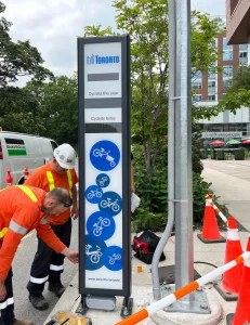
Automatic bike counters were installed in various locations across the city. Reddit image.
As well, collected data about bike ridership in the city is augmented by one of 15 automated bike counters, which operate 24/7 in dedicated bike lanes and multi-use trails criss-crossing the city. The city says it will install more counters this year, but recent reports already confirm record-setting growth and overall usage, with nearly a million rides taken in just one month this summer!
What’s useful and interesting about the many kinds of urban data being collected is that they are accessible on the City of Toronto’s Open Data Portal, a freely available online resource which gets updated regularly with data from thousands of sensors and completed studies in the city.
When such information is freely available, the theory behind the portal goes, anyone can use it to innovate, to draw insights about their city, to inform the design of civic features and services. The Open Data team encourages people to perform their own analysis, as many have.
Urban Sensors Track GIGO
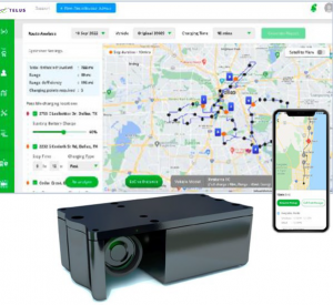
Street litter bins have sensors inside that electronically detect how full a bin is, display the information in an app, and relay the details to waste management officials.
Open data advocates certainly know the meaning of “garbage in, garbage out” when it comes to computer operations and the need to make use of collected data.
The acronym holds true when it comes to real garbage, as well.
Many folks have criticized Toronto’s public litter bins over the years, saying they are often overflowing with garbage, becoming unsightly and smelly.
But after the installation of high-tech sensors on more than 150 street litter bins in the past year, sensors that electronically detect how full a bin is and relay that information to waste management departments, service levels and cleanliness have improved, according to reports.
Walking and Talking Data, Sensors and the Public Space
In addition to the data it gathers, the City of Toronto also makes educational programs available to the public about its collection and the sensor technology it uses in public spaces.
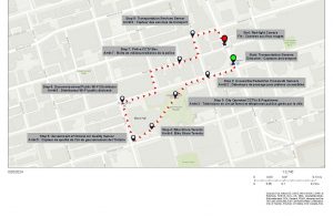
On one of the many Jane’s Walk walking tours held each year, City of Toronto staff guide participants through nine stops where sensors have been installed and embedded. Traffic management, air quality, public transportation, and other uses of data are discussed.
And programs like the annual Jane’s Walk event, during which people can walk and talk with city staff and learn about the types of sensors deployed, the kinds of data collected and the potential impacts on privacy. City staff are reportedly also exploring new ways to improve signage and public communications about the use of sensors in urban environments.
As the use of traffic tech, urban sensors, and public data collection increases, we as citizens should take advantage of programs and opportunities to know more about what is known about us.
# # #
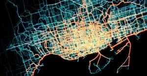
A visualization of data collected about Bike Share trips in Toronto shows record-setting growth and overall usage, with nearly a million rides taken in just one month this summer! Reddit image.
