A B.C.-based technology company has combined the power of artificial intelligence (AI) and super high-resolution imaging technology in an accessible new platform that makes hyperspectral image analysis accessible to anyone, no technical expertise required.
Hyperspectral images (very high resolution images that can detect and distinguish among light’s individual electromagnetic frequencies) can be taken either by in-orbit earth observation satellites or by land-based sensors; they’re used widely in sectors like agriculture, forestry, recycling, manufacturing, and natural resource management.
Data analysis of hyperspectral images is provided by a new artificial intelligence agent from the Canadian company Metaspectral. Photographed from space or on land, hyperspectral images convey very accurate information about different materials, substances, or objects.
The value of hyperspectral images lies in the huge amounts of data they contain. Unlike most cameras which capture imagery in just three spectra or light frequencies (red, green, and blue), hyperspectral imaging devices can capture data in up to 300 different light frequencies across the entire electromagnetic spectrum (visible and invisible, including infrared and ultraviolet frequencies). Image information is captured in real-time and pixel-by-pixel.
Data analysis of hyperspectral images can deliver very accurate information about different materials or substances: stuff can be precisely identified at the molecular level by its spectral signature, contained in the nature of the light it reflects.
So hyperspectral images can be used to find different objects or identify various materials, from the dust on the moon (for safe spacecraft landings) to man-made plastics (for sorting, recycling, and reuse) to pharmaceuticals (for safety and consistency) to chlorophyll (to gauge the health of vegetation) and much more.
They can be used to identify valuable assets (lithium deposits) or harmful substances (methane leaks).
But analyzing such ultra-high-resolution spectral images can be difficult and slow, due to the huge amounts of data they contain.
Metaspectral, a remote imaging and sensing software company founded in 2018, says its solution compresses data as much as 90 per cent while maintaining data and information integrity. Be it from a space-based satellite or an Earth-bound assembly line, Metaspectral’s expertise supports real-time hyperspectral image capture, data transmission, processing and analysis, and that can lead to fast responsive or corrective action.
Metaspectral also uses deep learning and its own trained artificial intelligence models to analyze the massive datasets generated by hyperspectral images, and its AI tools can identify hidden signals within the data that identify various materials or molecular substances.
Now, the company has unveiled an accessible AI tool that gives those hyperspectral satellite image analysis capabilities to anyone, even those without technical expertise.
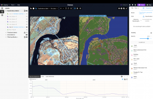
With the company’s Clarity AI agent now online, users can analyze hyperspectral imagery and quickly receive scientifically grounded answers. Without such a tool, the same process could take months of manual work by specialized experts.
“You’d need specialized skills and expertise to pull valuable insights out of hyperspectral imagery,” said Francis Doumet, CEO and co-founder of Metaspectral. “Clarity AI analyzes the image, runs target detection models, conducts background research, and directly displays the results for you.”

Francis Doumet, CEO and co-founder of Metaspectral.
Reached as the company was actively on-boarding users of the new tool, Doumet described how they can simply load a hyperspectral image to the platform, ask it a question in plain language, and wait for the platform to do deep analysis on the scene, sometimes in just seconds. (If you don’t have your own satellite, space-based images can be acquired from commercial or government sources; Metaspectral meanwhile can provide turnkey systems for earth-bound clients that include spectral imaging device, data collection and analysis, and related services.)
Clarity AI also searches and cross-references current event descriptions, as well as peer-reviewed journals, technical articles, and other relevant reports, to assemble expert analyses and display them on-screen. Interactive buttons in the user interface indicate the actions the AI is performing, allowing the user to maintain control and oversight of the analysis. Actionable, evidence-backed insights are delivered in text and graph images, and users can further interact with and prompt the agent for more detail.
As it develops its AI-driven imaging and analysis capabilities, Metaspectral has been boosted by over $1 million in funding from Environment and Climate Change Canada (ECCC) and CleanBC to apply the solution to recycling and the sorting of hard-to-recycle plastics. (The federal government says about 1.4 million tons of plastic film were generated in 2019, with less than four per cent of it being recycled, mostly due to challenges with collection and sorting.)
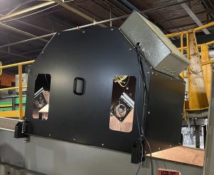
Hyperspectral images can be captured on a conveyor belt, and then analyzed with AI to help separate recyclable materials in real-time.
Because hyperspectral cameras make it possible to sort materials by their spectral signature at the molecular level, Metaspectral can process captured image data with deep learning and identify and separate materials right on the conveyor belt, and in real-time.
Metaspectral’s technology is already in use by some robotic recycling firms; it lets them tell the difference among different plastics, like the polyethylene plastic used in milk containers, the thinner plastic used in films, or those dense, harder-to-recycle black plastic containers.
Once the plastic’s been identified, commands are sent to a mechanical sorting device, be it a robotic arm or air injection system, to remove the item from the conveyor belt.
That’s an on-the-ground application; other important uses are from space.
Improved satellite-mounted optical sensors used by commercial providers can deliver finely-detailed views of Earth’s natural systems and human activity at resolutions of 0.3m² (about the size of large welcome mat). The hyperspectral sensors on satellites capture data at the molecular level (so they can identify soil, types, minerals, vegetation, particle emissions, water quality, and more). Synthetic aperture radar capabilities mean the satellites can “see in the dark”, penetrating clouds and smoke.
Due in part to these ever-increasing capabilities, the Canadian Space Agency recently announced a $5 million investment in companies and solutions that use satellite data to tackle biodiversity challenges, including projects to address declining species populations, habitat degradation, deteriorating water quality and forest disruptions.
Metaspectral is one of twenty Canadian companies, institutions or organizations, eight of which collaborate with Indigenous groups, selected through the CSA’s funding initiative, smartEarth, to be supported for its use cutting-edge satellite technology, artificial intelligence, and data analysis, to support biodiversity, protect endangered species, and defend the natural environment, often described as a big part of Canada’s heritage.
# # #
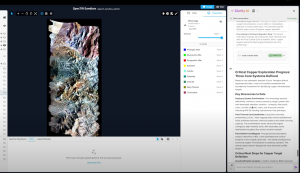
Clarity AI analyzes hyperspectral images, runs target detection models, conducts background research, and displays the analytical results on screen. Images supplied by Metaspectrum.
-30-