Maybe people who don’t live there should be asked how to fix Toronto’s transit mess.

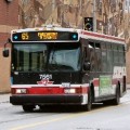
TTC buses can be tracked using a new open data based mobile app developed in Ottawa.
Because ‘out-of-towners’ have created Toronto’s newest real-time transit app using the city’s own resources: using the City of Toronto’s Open Data Policy and TTC’s real-time GPS data, TTC Bus Tracker app delivers up-to-the-minute information on bus location and predicted time of arrival.
The app is free to use, and because it is a web-based mobile app, it works on any device – smartphone, tablet, PC – and no downloads are needed. Just tap or type in the TTCBusTracker.com address, and get the information you need quickly, without signing or logging in.
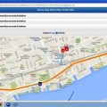
You can select, save and store oft-used routes or bus stops, and you can ‘live track’ your next bus as it moves through traffic – or not, depending on any congestion or disruption – and gets displayed on a Google street map.
(In my neighbourhood, there’s a huge construction project going on, affecting all local transit and traffic, so I found the feature quite handy; the TTCBusTracker showed itself to be right up to date, as well, identifying temporary stops and replacement bus routes nearby. This is unlike another Toronto transit app, which directed me to a stop which does not now exist, and told me to wait for a streetcar which will not be by for several months!)
The new BusTracker app is from Ottawa-based tech start-up Beyond 2.0, and it’s one in an integrated set of real-time multi-platform transit products they’ve developed, dedicated to serving commuters in each of several North American cities. Transit riders can check real-time GPS transit data anytime, anywhere, on any device, using their free app.
Beyond 2.0 launched TTCBusTracker.com less than a month ago, and the company has already followed up in Vancouver, Boston and soon Washington, D.C., adding those cities to the original Ottawa app.
BusTracker is a web-based mobile app, compatible with any device or platform.
“As regular users of public transit, Beyond 2.0 understands the needs of daily commuters and we have designed our app with them in mind,” said Ryan Androsoff, President and co-founder of Beyond 2.0. He was in T.O. for the app’s release, and yes, he got around town pretty easily.
Not just because of the app; he knows the city from the inside out so to speak thanks to the Open Data program, and open data in general: freely accessible and widely usable, open data from public sources has been used in the development of several apps, including those that provide information about water quality at beaches, food safety at restaurants, parking lots, bike trails and transit routes.
And while they’ve started with real-time transit apps, the long-term vision at Beyond 2.0 includes any number of unique applications and services built on open data.
They have two core products now: a real-time bus arrival display (a large screen digital screen that’s installed in coffee shops, shopping malls, community centres, or anywhere else near transit hubs or stops) and the Bus Tracker mobile web app.
Beyond 2.0’s business model for the Bus Tracker apps is based on giving local advertisers the chance to reach a geo-targeted audience with both banner and in-map advertising.
“Our experience in Ottawa has shown the value to advertisers of being able to use geo-locational targeting to reach transit users,” Androsoff explained, because users of the Bus Tracker app get information and maybe a coupon or two for products and services that are relevant – and nearby.
App users also get to select multiple bus routes at one stop, unlike some other apps, which presents travel options and choices. Unlike some other handy apps that are mobile only, the TTCBusTracker can be easily accessed on the home or office desktop PC, and because there are no downloads, it can be used on employer supplied corporate devices that are otherwise ‘locked down’ as a safety precaution.

A PC screen grab show transit vehicles tracked in real time and displayed on a city map using the BusTracker app.
-30-
submitted by Lee Rickwood


