As Canada and other countries around the world fight another deadly and destructive wildfire season, they’re being equipped with a new range of ‘fire tech’ tools, from artificial intelligence to social media to x-ray-like neutron radiography.
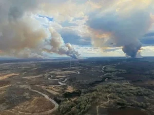
Smoke billows from huge fires on the landscape near Fort McMurtry, Alberta. Fire rage in the region again this year. Natural Resources Canada
Last year was the worst on record for wildfires in this country, with thousands of fires recorded, hundreds of thousands of people evacuated, millions of hectares impacted, and too many lives lost: wildlife, pets and livestock, civilians and first responders.
Make no mistake – despite the array of new technologies being brought to bear, it’s still boots on the ground that play the key role.
Firefighting crews (many of them volunteers, some recent trainees but others long-time servers of the public interest) are the ones on the front line, fighting flames, protecting property, saving lives.
Their tools have long included picks and shovels, backpacks and portable water sprayers, along with heavier equipment like bulldozers and water trucks and bombers.
But now, mapping technologies like GIS and GPS via full-size geospatial and low-level shoebox-sized satellites are in the toolkit as well. Fire-monitoring drones and other airborne vehicles equipped with multispectral cameras and computer vision equipment. Machine learning programs and proprietary artificial intelligence algorithms. Even user-generated content and hash-tagged imagery on social media.
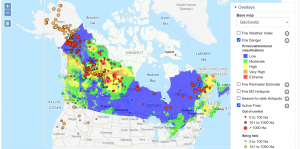
The Canadian Wildland Fire Information System (CWFIS) creates daily fire weather and fire behaviour maps year-round and hot spot maps throughout the forest fire season, generally between May and September. Screen grab July 4.
AI is seen as having great potential for predicting wildfire behaviour and marshalling responses to it, but the emerging applications face some limitations. The need for huge databases of information, the LLMs, or large language models that enable AI analysis and learning, just aren’t large enough – yet.
(It’s been reported that some 30 per cent of wildfires in Alberta were first detected by trained lookouts stationed in key areas. Ground and air patrols spotted another 30 per cent or so. Interestingly, so-called unplanned detection, like contact from the public, spotted roughly 40 per cent of reported fires. As part of the Alberta Wildfire Detection Challenge (link to pdf), six wildfire detection systems, using a combination of cameras, sensors, AI and machine learning, were tested. Lookouts – human observers – beat all the tech platforms tested, in successful detections!)
But even with limitations, the accuracy that some intelligent applications can come up with is a big advantage and those apps are learning all the time from new data input.
For example, Microsoft announced a year-long collaboration with Alberta and AltaML, an applied AI company based in Edmonton, to help fight wildfires. Both predictive and historical data were analyzed so firefighting crews could be best placed and best scheduled to fight emerging fire threats.
New on the scene are enhanced wildfire prediction platforms that make fuller use of artificial intelligence to accurately, they say, predict fire events up to 30 days ahead of time, and with a developer-cited accuracy rating of up to 90 per cent.
Headquartered in Calgary, with facilities in Toronto and Vancouver, Skymount Global says its new Firemark AI autonomous fire mitigation platform gathers and analyzes data from geospatial, UAV and optical sources to be much more than a predictive aid. It acts as an early warning system, a decision-making tool and a real-time guide for firefighting actions and remedies.
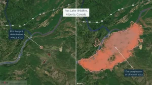
An example of a recent fire that emerged near Fox Lake, Alberta, captured on May 8, 2023, via OroraTech’s Wildfire Solution. Left image: The detection of the first hotspot on May 3, 2023. Right image: The fire progression after five days of burning.
As part of efforts at the Canadian Space Agency (CSA) to make use of wildfire monitoring satellites (and announced plans to invest $170 million CDN in a new wildfire monitoring satellite system), it’s been working with a German company called OroraTech to make use of that firm’s more than 100 shoebox-sized low orbit satellites and their capabilities (fire-spotting among the many abilities of such mini- or Cube sats).
During the 2023 wildfire season, OroraTech detected and monitored a fire near near Fox Lake in northern Alberta, where visible flames burned ever-increasing stretches of boreal forest for many days.
Images, data and AI are a powerful firefighting combination, from the visual to the geospatial to the hyperspectral, an advanced kind of imaging that reveals a much broader spectrum of light than the typical red, green and blue colour model still used by photo and video cameras today: it can ‘see’ fires in their earliest stages of heat and combustion.
On board the International Space Station (ISS), for example, there’s a hyperspectral imaging and data collecting platform from Vancouver-based MLVX Technologies, or Metaspectral. The company says it streams and shares image data captured from low Earth orbit, then applies deep learned AI algorithms and sub-level pixel analysis to quickly identify forest fires, methane leaks, oil spills and other such events. (Metaspectral is a Canadian entry in this year’s X Prize competition, in which millions of dollars are available drive innovation in firefighting technologies.)
Perhaps the judges have heard of social media?
That’s where another new firefighting tool has emerged.
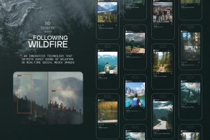
Photos and imagery tagged with #FollowingWildfire get scanned in real-time by a proprietary algorithm that identifies signs of smoke or fire. Following Wildfire (CNW Group/tentree)
Following Wildfire combines AI-powered technology with user-generated content on social media to detect signs of wildfires.
An initiative of Tentree, the Canadian sustainable clothing brand, this online campaign wants to get individual Canadians involved in the fight against wildfires.
Photos and imagery tagged with #FollowingWildfire get scanned in real-time by a proprietary AI algorithm that identifies signs of smoke or fire and assigns a risk level to the scene, based on regional weather, vegetation data, and other factors. Fire spread and burn intensity are also assessed.
Campaign managers say any images determined to be high risk are drawn to the attention of a trained moderator, who contacts the person who posted the image and, as appropriate, local fire prevention authorities.
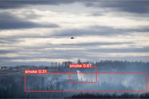
An example of a photo tagged with #FollowingWildfire and analyzed by its AI fire-detecting program.
Some sources of wildfires are not easily detected by remote sensing capabilities, and it is known that many fires are human-caused, so greater connections among Canadians and firefighting officials is welcome. Images, information and data generated by such initiatives can help build the large databases needed to better train AI firefighting agents.
The FollowingWildfire campaign is aimed at Canadians in wildfire-prone areas, as well as environmental advocates, wildlife protection groups, local authorities, tech enthusiasts, and people who enjoy camping and hiking.
No matter what an image shows (clouds or smoke, controlled cooking fire or raging inferno), Tentree advises all campaign participants to follow official fire guidance and warnings if and when given.
In case of a suspected wildfire, people are advised to “please immediately contact your local authorities and act with common sense.”
No artificial intelligence required.
-30-